Thoughts on Portland’s Greenways report

Earlier this week the City of Portland put out a report on their neighbourhood greenways (historically called neighbourhood bikeways), which like Vancouver, formed the backbone of their biking network for several decades. There has been a lot of talk in Portland about the frankly terrible conditions that some of the greenways have descended into: lots of fast moving cars making biking downright uncomfortable and dangerous.

greenways poster map FINAL v2013
Map of Portland Greenways – 2013

What makes the report interesting is that is the first that truly digs into the existing conditions and sets out clear targets for greenways, which have traditionally get a sign and not much else (as anybody riding on Vancouver St or Haultain in the City of Victoria can tell you). Looking at the report, I had a few thoughts about what it gets right and what could be improved.

What the report gets right

It exists

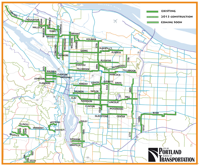
No other city that I know of has done a comprehensive look at their greenways/bikeways in this way, especially looking at motor vehicle volumes and speeds. Kudos to PBOT for taking this one.

It highlighted the role a greenway plays beyond biking

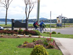
Bikeways were rebranded greenway to recognize that their role goes far beyond making biking more comfortable for the All-ages and Abilities crowd. Portland has been great about creating people-spaces along these greenways.

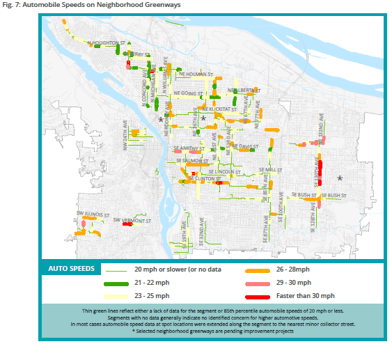
The focus was on reducing motor vehicle speed and volumes

In the grand scheme of things, nothing else matters. Bioswales, signage, wayfinding and pretty pavement don’t matter unless the number of cars and how fast they are going drops

PerformanceGuidelines

It sets targets

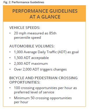
Neighbourhood bikeways lack good design criteria. Unlike say, a bike lane, there isn’t a set of universally accepted standards. There were informal numbers, such as 1,000 cars per day, or 30 km/h, but until now nobody has truly coded that into their policy documents in such a strong way. This report lays it out in bold, clear terms, allowing staff, councils and advocates to start a conversation at the same place.


What needs some work

Cartography

Sorry PBOT, but “No Data” and “Meets the Standard” are completely different. No Data means just that; conflating it with areas that have been tested and meet the standard tells us nothing. PBOT should reissue these maps clearly separating out No Data from Meets Standard.

No data ≠ meets standard

Acceptable vs maximum

The report rather sets out 1,500 cars/day as the acceptable, but 2,000 as the maximum. But bizarrely, from 1,500 to 2,000 cars per day is unacceptable, yet action is only taken until the number passes 2,000. Given that traffic volumes can vary huge amounts per day (30%+), the threshold for action should be 1,500, not 2,000.

(Yes, I am aware of the Oregon-specific legislative requirement regarding speed limits and cars per day)

Final Thoughts

All in all, an excellent report that other cities should emulate. Neighbourhood greenways/bikeways are such an important part of the city fabric, both for bikes and more, that

If you want to read more, I suggest any of the posts on the topic by the always excellent BikePortland:

New activist group off to fast start: First protest ride is tonight

Council vote today would allow more diverters on neighborhood greenways

Neighborhood greenways breeze through council with unanimous support

CRD gets federal gas tax money for PCMP implementation

Finally announced, the CRD recently received $780,950 from the Government of Canada’s Gas Tax Fund transfer to implement various part of the Capital Regional District’s (CRD) recently completed Pedestrian and Cycling Master Plan (PCMP). The full announcement can be found on the Canada News Centre or from the CRD’s 2013 Media Releases.

Excitingly, this means a whole series of pilot projects for all the “E”‘s from the PCMP, including Engineering aka infrastructure such as:

Bike activated warning signals
Such as HAWK beacons

HAWK signal
HAWK signal (Image credit: Wikipedia)

Advisory bike lanes (Minneapolis has a few)

Advisory Bike Lane in Minneapolis
Advisory Bike Lane in Minneapolis (Photo credit: City of Minneapolis)

Traffic calming for bike boulevards

Traffic barrier at Haultain and Shelbourne
Traffic barrier at Haultain and Shelbourne (Personal photo)


Other engineering projects include solar-powered signage, automated count stations, and secure lock-up systems that support dual-mode trips such as cycling and transit. The “soft” E’s including Education and Encouragement, Enforcement, Evaluation aren’t left behind either. Should be fun times!

(Full Disclosure: I work for CRD Regional & Strategic Planning and am the Bicycle Count Coordinator for the CRD)

Oak Bay’s Active Transportation Advisory Committee is blogging

Kind of late to this party, but they don’t seem to have much Google-juice (they are page 7 on my search for “Oak Bay Active Transportation”), so here it is: Oak Bay Active Transportation at Blogspot.

Their recent Complete Streets policy is a great start, here’s to many more successes for them.

Making the Haultain bikeway better

As we have now passed a slightly wet June and the weather is getting better, I thought now would be a great time to share some ideas about improving the cycling infrastructure in Greater Victoria. Let’s start with my ride to work: the Haultain bikeway. This is already one of the best east – west connectors in the core but it needs some work to make it great.

Why Haultain?
Flat – unlike Fort to the south and other roads to the north, Haultain is largely flat.
Quiet – Haultain has very low traffic volume, likely because of the traffic calming that already been done
Already traffic-calmed – Saanich and the City of Victoria have already spent money and effort making Haultain pleasant for cyclists through closing off intersections and adding speed humps.
Existing connections – it already links many other regional bikeways including the Seaside Touring route, Dean Ave, and via Cedar Hill/Walnut/Chambers/Caledonia gets you to Vancouver St.

So if it’s so great, what needs to be done?
Designating it as a bikeway
None of the three (Oak Bay, Saanich or the City of VIctoria) jurisdictions that Haultain cross designate it was a bike way.  It is identified as a route in the Oak Bay Active Transportation Strategy (an unofficial plan) and the it is part of the CRD’s PCMP Primary Inter-Community Network, largely because those of us who helped craft that document insisted on it.

Repaving Haultain in Oak Bay
To say that the road here is terrible is an understatement. Unlike sections further west, there has been no recent paving here.

Prevent through motor vehicle traffic at Haultain and Foul Bay
This intersection needs a barrier like the intersections at Richmond and Shelbourne.

Widen the crossings as Richmond and Shelbourne
Neither of these intersections are wide enough for the volume of traffic through them.

Add traffic calming on Haultain between Shelbourne and Cedar Hill Rd
This section can have fast moving vehicles, but adding traffic calming is impossible unless BC Transit removes the 22, something they are already talking about doing.

Add a connection to the Vancouver Street bikeway
Haultain’s biggest problem is this lack of link. Although such a link exists via Cedar Hill and Walnut St in the official City of Victoria bicycle plan, but nothing actually exists on the ground.

Over the next few days I will be sharing a section by section view of the bikeway with specific recommendations on how to make it better.

What I read last week

I try and stay on top of new research which pours in. Usually I fail, but here are the papers I managed to get time to read last week:

Emergency Response and Street Design Initiative
Lead by the US Congress of New Urbanism(CNU), this report is a call to new urbanists and fire departments to talk more about traffic calming, especially street narrowing. Many emergency responders, including fire departments, oppose traffic calming because it is perceived to slow response time. Anecdotally, I know from speaking to residents along Hampshire Road that the Oak Bay Fire Department was instrumental in preventing traffic calming on that road, which is heavily trafficked, and has major speed issues. This report is part of CNU’s Emergency Response and Street Design Initiative. More information about the topic can be sen on the Strong Towns blog under “fire trucks“.
[download id=”14″ format=”1”]

Transit Bus Life Cycle Cost and Year 2007 Emissions Estimation Final Report
This report, although 4 years old, looks at life-cycle costs of various types of buses, including compressed natural gas (almost unknown amongst Canadian transit agencies, but popular in the US), various types of diesel, and diesel hybrids. The biggest problem with the report is that it doesn’t account for the massive spike in fuel costs in 2007, which changes life-cycle costs considerably. Still, an interesting read.
[download id=”13″ format=”1″]
(note: Although I downloaded the original report from Proterra, an electric bus manufacturer, the report is from the US Federal Transit Agency and the West Virginia University’s Center for Alternative Fuels, Engines & Emissions)

One All Candidates done, one to come

Well, one all candidates is done. Speaking last was the distinct advantage of getting to listen to everybody else, but you do get to stew in your own nervousness for over 20 minutes while everybody else talks. Jason Ross of ModernDemocracy.ca was there again with his video cameras, which was excellent, so those you following at home can see. I tried collect all the questions I could while they came up, and I think I managed to get most of them:

  • Child care – How are you going to provide more spots?
  • Secondary suites
  • Traffic on the avenue – How are you going to deal with heavy traffic on the avenue and surrounding residential streets
  • Young families – How do you attract more to Oak Bay
  • Affordable housing – How to you provide more
  • Town hall meetings – Why haven’t we had more?
  • Oak bay lodge
  • Smart meters, and health
  • Deer issue – What is Oak Bay and the CRD doing about it?
  • Community engagement young families – How do you engage young families in the community
  • CRD accountability
  • Sewage infrastructure
  • P3’s water/sewage – Do you support keeping water and sewage infrastructure and operation public
  • Composting -When is it coming to the rest of Oak Bay?

Thanks to everybody that came out. If you missed it, we have another opportunity next Tuesday, November 7th, 7-9pm, at Emmanuel Baptist Church. Thanks to the North Henderson Residents Association and the Community Association of Oak Bay for hosting these.

Will they be concerned when somebody gets killed?

Bowker & Cadboro Bay Intersection. Photo credit: John Luton

The Oak Bay Police are claiming that the intersection of Bowker and Cadboro Bay Rd. isn’t a problem, because most people do the speed limit. Let me rephrase that, while the police watched, people didn’t speed. Colour me not shocked.

Having lived on Cadboro Bay Rd for just over three years, if most people are doing the speed limit, I would be truly surprised. I can definitely say that the width of the road encourages people to speed, as the picture to the right shows.

As I have mentioned before, pedestrian fatality percentage rises sharply between 30 and 60 km/hr. 5% to 85%, to be exact.

Cadboro Bay Rd width. Photo credit: John Luton
Looking north on Cadboro Bay Rd near Willows School. Photo credit: John Luton

So what can be done about it? A traffic circle is very needed, but before that there are three simple steps to keep speeds down:

  1. Bulge out the sidewalk at the crossing near Willows School. This shortens the crossing and puts the pedestrian beyond the parked car and in the sight of any oncoming vehicles.
  2. Bulge out the sidewalk at the two ends of the school zone. This narrows the roadway, slowing drivers down.
  3. Add bike lanes. The road in front of my house is ~11m wide, which is enough for two 3m travel lanes, two 1.5 m bike lanes and one 2m parking lane on the west side of the road. The loss of parking on the east side is mitigated by the fact that few people park on the east side of the road most of the day anyway.

Will any of this happen? I hope so. It will take a lot of work to convince council that these steps are needed to keep kids and people of all ages safe. Maybe they should be reading this pedestrian injuries report from Safe Kids Canada.

A daily grab-bag of links

The world keeps turning, even if I have been crazy busy with various non-bike relating things. So I present a grab-bag of fun links and commentary on news stories:

  • Packed in like sardines. It is a cliche and yet our buses (and public transit across the world) often feel more like a can of fish than a pleasant way to travel. To drum up political support for fixing the problem, a couple of Swiss decided to ride around dressed literally as sardines.
  • After dropping off my grandmother at a ferry today I got caught by this accident on Cordova Bay Rd. Apparently the cause was an 82 year old man having a heart attack. Why are we still building cities that require 80+ year old people to drive?
  • Speaking of my grandmother, two Saanich workers scared the crap out of her the other morning by walking into her back yard, looking for a storm drain cover. Turns out they were looking for the source of this oil leak into Douglas Creek, a salmon-bearing stream which runs through Mount Doug Park right behind her house.
  • Arthur Erickson, Vancouver architect, has died. He had a bit a love for concrete and brutalist buildings but also did a lot of good work including a building in the Downtown Eastside of Vancouver.

There has also been a whole host of news about community planning today:

And lastly,Transportation Alternatives, a bike and ped advocacy group in New York City that has gone from guerilla activism to advising the city’s Department of Transportation, has launched “Biking Rules: A new street code for NYC Bicyclists” campaign that is coupled with a slick website that also allows users to show safe biking routes they have found (via Streetsblog). The map is driven by data from OpenStreetMap. More of that free data empowering people and communities again.

Pictures from Sidney’s celebration station today

long shot of celebration station from the north
Long shot of celebration station from the north

To celebrate the first day of this years Bike to Work Week, I made the trek up to the most northerly celebration station in south Sidney. Today’s big story ended up being the weather, with a little bit of rain, sun and just about everything in between.  We were right along the water near the Anacortes ferry terminal. This meant there was a very stiff breeze from the south, so much so that at several points the half dozen of us all had to hold down the tent to literally keep it from blowing away.

I ended up staying just over an hour and in that time we saw about a half dozen bicyclists. Amongst that group was a recumbent, who along with his partner, were on their way to Tijuana and a tandem heading south. I am not certain if it was the distance or the cold weather but every cyclist we had come was seriously equipped. Hopefully we get some better weather over the next few days to get those occasional riders out.

See you all tomorrow at the UVic fountain between 6:45 am and 8:45am.

Tent of the celebration station in Sidney
Tandem riders leaving celebration station
Pumping up the tires on a recumbent