The guerrilla sharrows that have appeared on Lansdowne just south of Camosun College have made the news. A few days ago, the press release from OURS hit my inbox. I have been ruminating on what to do with it since then. I really don’t support what they are doing and I don’t really want to support their cause by publicizing what they are doing. But given the Times Colonist has now covered them, my little blog is small potatoes.
I do have one question however: Why are they attacking the City of Victoria when they painted the sharrows in Saanich? It isn’t like Saanich doesn’t also have a bicycle network plan (PDF, from the Saanich Official Community Plan site). That section of Lansdowne is even on it.
The E & N Rail Trail, boldly promised to be finished by “the 2010 Olympics” just a few years ago by the CRD (PDF), is now finally taking shape in Langford. I thought I would bike out there and see how it measured up.
For starters, this little section of the trail is tiny. Much like the Bowker Creek Greenway in Browning Park I talked about, network effects mean that both trails will get few users until such time as more of them are completed.
E & N Rail Trail Map. Map data: OpenStreetMap/OpenCycleMap
Starting for the westernmost side on Atkins Road, the trail starts with a very old pedestrian bridge over the trail, which was created for the students of Savory Elementary School. On the other side of the bridge you are dumped into the school yard about 50m from the actual start to the trail.
]The old pedestrian bridgeMural, with parking to the right
The trail itself is straight and fairly flat, although immediately the potential for conflicts with the adjacent parking lots became apparent. Why the CRD/City of Langford didn’t choose to at least bollard off this I don’t know. As it is, it is far too easy to drive onto not only this section of trail but also one other section west of Phipps Road.
Murals, with parking to the right
After crossing Veteran’s Memorial Parkway at Goldstream you wonder where the trail went. I really hope this is a temporary thing (there were construction signs everywhere along the trail stating it wasn’t open yet) because you can see just how bad it is.
East of Veteran's Memorial Parkway, the connection to the trail is sadly lacking.
At the other end of this section, the section between the sidewalk and the trail is likewise unfinished. But that isn’t the worse part about the Peatt Road crossing. For some unknown reason, rather than just crossing in parallel with the rail line, you are forced to travel south to the intersection, cross Peatt there, then along the sidewalk, cross back over rail line (as of yet unfinished) and to the trail. Utterly ridiculous.
The Peatt Road crossing
The other end of the trail (and current westernmost end) just dumps you out onto the sidewalk. No indication where you could go next for another trail, etc. I realize that the trail’s costs ballooned, but still. A simple sign directing you back to the Galloping Goose would have been nice. At least it has a connection to the road.
Westernmost end of the trail
And thus we finish this section of the E&N Rail Trail. It is a great start but there are a few head-scratching decisions here and there. Hopefully these can be fixed but it is better to get it right the first time. Let’s hope the CRD and their member municipalities open up the design phase a bit earlier so that these mistakes can be caught and corrected before they are concrete (literally). To see larger versions of these pictures (and a few others) see my flickr set.
The Bowker Creek Greenway is starting to appear in Browning Park in Saanich. As I mentioned last fall, it is funded by provincial money via LocalMotion and federal stimulus dollars. When I was there yesterday, the asphalt had been poured but the construction fencing was still up. This wasn’t stopping people, as the new, very black asphalt was covered in footprints, of the human and canine variety.
Browning Park with approx. trail location
Later that evening I spoke with a Saanich Parks rep (at an event on a new 20 year plan for the Cadboro Bay Gyro Park) about the greenway and he stated the last work left to do was some curb cuts and some concrete. He didn’t give me a timeline but the amount of work is pretty minimal so I don’t expect it to be too long now.
One of the sad parts about this project is that the trail likely won’t see a great deal of us because it is isolated in amongst the very car-centric Shelbourne Corridor area (although the whole corridor is being rethought, as I reported a few months back). The next pieces should be easily to get built, because now they are extensions onto an existing trail, not the creation of a new trail whole cloth.
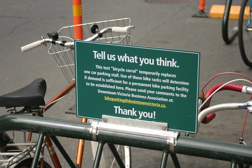
Here in sunny Victoria there are currently just two in commission: one (in the picture to the right) is in the 700 block of Fort St. by Shavers Hobbies, just east of Douglas and the in the 600 block of Johnston St. across the road from MEC, east of Government. Both seem to be fairly well used over the past few weeks, so I expect to see more appear very shortly. After all, over 30 businesses expressed interested in removing a car parking spot in front of their business to adding bike parking (DVBA press release April 14 – PDF).
But don’t just use them. The DVBA and their partners are looking for feedback, so email them and tell them how much you love them.
With Phase 1 complete, the next phase of the CRD Pedestrian and Bicycle Master Plan is afoot. There is a public open house on the 29th of June from 5pm to 8pm. It will be held in the lobby of the CRD Building (625 Fisgard St). More details below:
After a good half hour debate about the relative merits of adding bike lanes and bike boxes on two different routes to UVic, council ultimately decided to delay doing any work until Director of Engineering David Marshall could come back with more detailed engineering drawings, traffic counts at the Foul Bay intersection, and feedback from the local residents affected.
For a quick review, as I reported two weeks back, Councillor Nils Jensen asked Marshall to look at adding a bike lane northbound on Foul Bay just before Lansdowne Rd with a bike box at the intersection itself as well as adding a bike lane on the western section of Cedar Hill X Rd to complete the existing lane that ends at the Saanich border.
Marshall came back with three different designs: The first simply stripped the bike lane through the intersection, possibly with a coloured treatment in the middle for visibility. This was the option recommended by Marshall to council. The second added a bike box at the intersection and the third extended the bike lane all the up the curb, removing the right turn lane.
Also completed was a quick count of cyclists, with 54 cyclists tallied headed northbound during peak hours a few weeks ago. Engineering staff also spoke to a few of them. Their main concern was with how the intersection shifted to the left as a bicyclist or car travelled northbound. This apparently low number of cyclists and their lack of concern was used by several council members as reasons for holding off doing any work. Given that neither UVic nor Camosun are in regular session, the numbers are deceivingly low. I also suspect that surveying now misses the inexperienced cyclists that appear in the early September, cyclists that are more likely to want bike lanes and bike boxes.
At the end of the night, council ultimately opting to do nothing beyond asking Marshall for the more information. Hopefully the Community Initiatives Committee, of which I am a member, will meet again in the near future so that we can discuss these items and get some action before the summer ends and students return to class.
Bike lane ending on Foul Bay. Photo Credit: John Luton
Bicycle commuters to UVic may have an easier time next September as the municipality moves to fix a few gaps in the existing bike lanes. Initially promoted by Councillor Jensen, Council last night asked engineering staff to prepare a report on finishing the bike lane on the northbound (east) side of Foul Bay just before Lansdowne (as can be seen on the photo to the right). This is a very steep area and the bike lane disappears a few hundred metres before the intersection. Further the study will look at the addition of a bike box at the intersection itself to help get bicyclists get ahead of cars. Given that the roadway narrows and shifts to the west at Lansdowne, a bike box will help keep cyclists safe and make them feel more comfortable.
Also up for study is finishing the bike lane on Cedar Hill Cross Rd from the Saanich border (near Mount Tolmie Park) to the entrance of UVic. This part of Cedar Hill X was recently repaved, a missed opportunity to get these bike lanes in as part of the re-striping of the road.
Bike box being installed on Wharf. Photo Credit: John Luton
Much of the discussion around the table, which was missing bike lane skeptics Cassidy and Herbert, focused on the process, given that the municipality has tasked the Citizen’s Initiatives Committee (CIC) with pedestrian and bicycle improvements. The Mayor wanted the study to got to that committee first, before coming back to council but in the end settling for sending it Comm. of the Whole. This far more informal venue will be a good place for council to get feedback on the proposed changes. That report is expected to available by the June 7th Comm. of the Whole meeting, held at the municipal chambers.
All in all, it is good to see this low hanging (or lying on the ground fruit, as Coun. Jensen put it) dealt with so that the CIC can handle the larger, more contentious issues such as Beach Drive or Cadboro Bay Rd.
Between ATVs and the Colwood Council, CRD has found its parks under a great deal of strain recently. The local ATV groups have started a drive to allow ATV access to the regions parks. Then Turner Lane Development Corp., the developer of the mostly-dead Colwood CornersCity Centre Colwood, has managed to get the Colwood Council to sign off on a hare-brained scheme to re-route the Galloping Goose and use its right of way for a road.
First, the ATVs. Loud, polluting, and ecologically destructive, these little beasts have their supporters. So much so that the local advocates have managed to get access into the local consciousness. The mere idea that ATVs could get access to local parks seemed completely off the radar until very recently — even CRD Parks own FAQ doesn’t even mention motorized access — and the ATVers have run a very slick campaign, catching most of the environmental groups and like-minded people off-guard.
However, I seriously doubt that ATV access, even if granted, will last for very long. If they are lucky, they will get agreements like South Island Mountain Bike Society (SIMBS) have with CRD over mountain-bike access to Hartland. Those agreements have some pretty strict termination clauses (see this access approval over a technical training area) and I know SIMBS has run into issues in the past. The major problem that the ATVers have is that the damage a mountain-bike can do to sensitive terrain is nothing compared to what even a single ATV can accomplish (an object example of this). So even one or two yahoos will quickly bring the ATV crowd into conflict with the CRD.
The other lunacy running around is the idea to re-route the Galloping Goose alongside the Old Island Highway and use the Goose’s right of way for a north-bound road. This one also appeared from nowhere and even managed to get the Colwood Council to sign on to the idea, unanimously no less. I can confidently predict this will fail. The last time a developer attempted to get the Goose turned into a road, an extension of Harbour Road for the Railyards in 2002, it was killed. Eight years down the road, there are only more bicyclists, walkers and other users of the Galloping Goose so getting people out to oppose this should be easy.
Thankfully both of these ideas require CRD Board approval. The next board meeting is April 21st at 9:30am in the CRD Boardroom at 625 Fisgard. If you want to speak, you will need to get prior approval. I will be Hawaii running up my carbon debt so I won’t see you there!
The CRD Regional Pedestrian & Bicycle Master Plan (PCMP) is having its next public event on March 11. The event will cover the completed first phase of the plan, including the unveiling of the Bikeway Inventory Map. The plan, which launched last year, has already gone through some initial collection of public input. As has been the case with previous events, project consultants Alta Planning + Design and CRD staff will be on hand to discuss the next steps. I strongly encourage you to come, for which you need to register on the CRD PCMP page.
Police remind motorists who park their vehicles in the bike lane along Henderson Road that doing so is a safety concern, not to mention a violation of municipal bylaws and the Motor Vehicle Act.
Offenders can be towed and ticketed.
I have called in dozens of vehicles parked in the bike lane since it was installed, but anecdotally, the number seems to be shrinking. My hope is also that of John Luton, who says in the notes attached to the picture on the right:
Hopefully, parking will simply disappear as a use along the corridor and the full time bike lane concept realized someday.