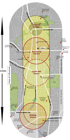
Saanich has recently launched a project to rethink the Shelbourne corridor, or at least the section from the Victoria border to Feltham Rd. in Gordon Head. The project is partial update to the venerable Shelbourne Local Area Plan, last changed in 1997. To kick off the whole thing off, Saanich held an open house to ask for people’s opinions on what they think should be done. I managed to make the last hour of the open house and collected a few notes.
Clearly evident was that Saanich is still very much in the information gathering phase. Of the nearly two dozen large boards spread around the room that showed everything from traffic volumes to population densities and average ages to zoning, only one of them had a recommendation on it. That was the proposed Bowker Creek Greenway project, which confusingly does not follow the path of the now-culverted Bowker Creek beside Shelbourne. Not surprising, this was the board that attracted the most interest and more comments. All of the rest of the boards were about the current state of the corridor today, to help people with context for their suggestions.
To hep run the event, Saanich had invited members of the two community associations that overlap the study area, Mount Tolmie and Camosun. They had also generously given space to a number of community groups including the Bowker Creek Initiative, who have just launched their draft 100-year vision which partially overlaps with the Shelbourne corridor, and the Shelbourne Memorial Tree Project, who seek to remind people that Shelbourne was planted with trees in 1921 as a memorial to the lost soldiers of the First World War, designed to deliberately invoke memories of France’s leafy avenues. Also in in attendance was UVic’s Office of Community Based Research, who have been working with Green Map project around Victoria. OCBR’s Maeve Lyndon, who came to talk to Oak Bay Rotary about the CBR and the Green Map, Theresa, and Ken Josephson, who recently worked on the Oak Bay Green Map, due for launch tomorrow evening were all in attendance.
Beyond providing information, Saanich was also interested in collecting people’s visions for the corridor and thus the questionnaire they handed out not only had a few questions about where you live and how often you use the corridor and how, but had a large map of the corridor on the other side, for free form drawing and collecting of ideas. I don’t envy the planners who now have to decipher hundreds of people’s scribblings and make a coherent report out of it.
One of the groups clearly missing was Hillside Mall. Although they are wholly within the City of Victoria, much of the traffic that comes to the mall drives on Saanich roads. They also recently finished a new plan, although the details of that haven’t been released yet. Their Renovations page still says “Watch this space”. I also understand from talking with the Bowker Creek people I have talked to that their plans don’t involve daylighting the creek, which currently runs on the western edge of the mall, by Doncaster Road and Thrifty Foods.
If you want to give them feedback, they sadly don’t have the PDFs of the boards they had up online yet, but the Shelbourne Corridor page on Saanich’s website lists contact information for the planner in charge of the project.
One thought on “Rethinking the Shelbourne Corridor”
Comments are closed.