Volunteer this summer

If you are looking for something interesting to do this summer, why not volunteer? There are a lot of places that you can do it, but here are a couple that might strike your fancy:
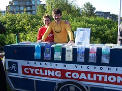
GVCCs whale. Image Credit John Luton
GVCC's whale. Photo:John Luton

July 1st – Canada Day Picnic on the Gorge Waterway Park with the Greater Victoria Cycling Coalition – 10:00am – 4:00pm

The GVCC is looking for people to help at their mobile information booth, otherwise known as “the whale”, probably because it handles something like one. At least 4 volunteers are needed, although the more the merrier.

July 4th – MEC BikeFest in Market Square with the GVCC – 10:00pm – 3:00pm

As with the Canada Day event, they are looking for people to help out at with “the whale”. This is MEC’s first event of its type and is designed to attract the bicycling members of MEC. This is a great opportunity to connect with this potential membership base. At least 4 volunteers are needed, although the more the merrier.

If you are interested in helping out with either of these events, contact Darren Marr at dkmarr@shaw.ca by Saturday the 28th.
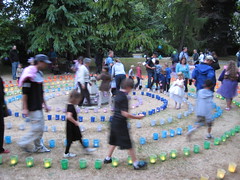
Labryinth at 2008 Luminara Photo:Brian Burger

July 25thLuminara in Beacon Hill Park

The Luminara people are looking for more volunteers to help out with setting up and taking down the lanterns as well as other work. If you can’t volunteer on the 25th, there might be spot still available in the days before. Contact Audrey Deutschmann at volunteer@luminaravictoria.com or 250.388.4728 ext. 130.

August 2ndSelf-Transcendence Triathlon and Duathlon in Elk Lake Park

They are looking for people to marshall foot and bike races. You need to be there by 7am, so this is one for early birds. Email info@scmt.ca or call 250.592.6211 for more information.

If these events don’t do it for you, Volunteer Victoria’s Volunteer Database is the clearinghouse for all sorts of interesting volunteer jobs, both this summer and ongoing. Have fun and happy volunteering!

New approaches to street design

Sharrows on San Juan Ave near Shelbourne

Spacing Toronto, an excellent blog by the equally excellent people who create Spacing magazine, is running a well written piece on new approaches to street design. The key point made is that what we have done in the past, both being car-centric and using  cookie-cutter  designs isn’t going to cut it anymore. They use the example of Annette St. in Toronto, which was to get bike lanes but then was downgraded to sharrows instead. Very much the Monterey Ave. controversy last summer (Committe of the Whole minutes: Aug 11 & Oct 6).

Complete streets are something I have mentioned here before and I truly hope they are catching on around here as well. San Juan Ave isn’t the only street that Saanich is working on and the CRD is working on their new Bike/Pedestrian Master Plan. Here in Oak Bay the Bike Master Plan a group of us are building is ticking along quite nicely, but we are always looking for more people. Email the projectteam if you want to help out with bike counts, mapping or anything else.

Notes from yesterday’s BCTransit open house

The latest in the seamingly endless studies about rapid transit is entering it’s public consultation and thus BCTransit is holding a series of open houses.This one is called the Victoria Regional Rapid Transit plan and  managed the first open house yesterday at the Legion Hall on the Gorge. I doubt this will be the last study. If you want a good idea of just how often this has been studied, see page 2 of this PDF. I must confess all this leaves me just a little jaded.

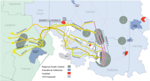
Potential corridors for the VRRT project

This specific plan is an outgrowth of the recently-failed Douglas St. busway, which did yield one concrete result: BCTransit now owns the right of way to the centre 2 lanes of Douglas St. north of Fisgard. Unlike the Douglas St. plan, this one doesn’t presume the use of specific corridor, rather they are looking for input on what corridor they should be using. See the map to the right or the full PDF for the options.

For the Downtown to Uptown route the logical route is Douglas St, as we already own the corridor, it would require less work than Blanshard St and the potential, with the right technology (ie. rail), to stimulate a lot of needed development in the north Douglas area.

From Uptown I think we should run with the Trans-Canada Highway and the Galloping Goose. Between those two alignments there should be plenty of room to run two full tracks while keeping the existing trail and the highway. It also passes right by the Victoria General Hospital, a major employer.

It should then shift to the E&N Railway when it nearly joins the highway in View Royal, because the corridor is already publicly owned (by the Island Corridor Foundation) and it runs straight into downtown Langford, where they have just finished building a beautiful new transit station.

As for technology, they claim that they have no bias one way or the other, but as I have pointed out before, I really doubt that. Maybe by picking at least part of the E&N, they will be forced to use rail.The plan is for the prelimiary consultation to be done by the this fall with the larger work starting in 2010. Implementation is 2011 or later. Likely later, given there is no concrete funding  from any level of government. Interestingly, this timeline aligns very neatly with the new CRD Bike/Pedestrian Master Plan. I wonder if they have been talking with each other…

But don’t take my word for it. There are two more consultations: one tomorrow in Colwood and next Monday at Victoria City Hall. See the schedule for more information as well as PDFs of most of the handouts. As an aside, this also the 100th published  post on this site.

Come support Oak Bay Sea Rescue tomorrow night

Dallas Rd. storm
Dallas Rd. storm. Photo credit flickr user dewolfe0001. License CC by sa 2.0

Tomorrow night the Oak Bay Sea Rescue Society, Coast Guard Aux. Unit 33, is up before council for a rezoning request for their new boat house. The Times Colonist has covered the story half-decently, but I thought I would point out a few more things

1. The $4,000/year they are paying for rent for their second boat could and should be used for rescue equipment, like an automatic debribulator that they want to buy.
2. If they don’t get it built this season, their new boat risks serious damage in the upcoming storm season

3. The Oak Bay Marine Group has never seen fit to actually attend any council/comm. of the whole meeting where this has been discussed in the past 6 months, despite being invited. In contrast the OBSR has been out at every meeting and sat patiently to get their turn to speak.

4. The new boat house will only be slightly larger (about 10′ longer and about 5′ wider) than the existing boat house. From Beach Drive I seriously doubt anybody will notice the difference.

Lastly and most importantly: This is an all volunteer outfit that protects you, the average user of the water. As Jeffery Dubney of the society said to me,

Members risk their lives for others and they should not
have to prepare for a mission at 2 AM  in sub zero temperatures by being
forced to put on protective clothing outside in driving rain in 50 mph winds
because there is no room in the existing boat house.

It usually isn’t during the sunny, nice days they called out. It is times like this storm on Dallas Rd. in the picture that they go out and rescue people who have gotten into trouble. So come out tomorrow at 7:30pm at the Municipal Hall and support the Oak Bay Sea Rescue Society in their bid to provide better service for all users of the water.

Things to do this weekend

The Victoria Francophone Society is hosting St. Jean Baptiste Day in Willows Park this Saturday the 20th. The event runs from 12pm-5pm with lots of free music and dance all afternoon long, kids’ entertainment including giant games, bouncy castles, sumo suits & crafts, as well as poutine & treats on sale for all. Cost is by donation. More info at harbourliving.ca.

The Old Cemeteries Society of Victoria is holding a Father’s Day walk with Sunday the 21st starting at 2pm at the Starbucks in Fairfield Plaza. It is hosted by Mayor Chris Causton and will lead people to graves of notable Oak Bay residents. Cost is $5 for non-members, $2 for members. If you miss this one, there are lots more tours this summer on different subjects.

Oak Bay sewage forum tomorrow night

After popular demand by our very own John Herbert, the CRD has added a public consultation in Oak Bay tomorrow evening at Emmanuel Baptist Church (2121 Cedar Hill X Rd (google map), right by the entrance to UVic) between 3pm and 8pm. As Cllr Herbert said:

“If they’re proposing to have one of these sites in Oak Bay, then they need to have a meeting in Oak Bay to allow the residents to have their say.”

While I disagree with John Herbert on a great many issues, this is one of the few of them that we actually agree on. See you all tomorrow night.

Notes from yesterday’s CRD bike/ped plan launch

The CRD is building a new bike and pedestrian master plan and to get the ball rolling, they hosted a launch & lunch party yesterday and they were kind enough to invite myself, Lesley Ewing and Gerald Smeltzer, all of us on the core team of the Oak Bay bike master plan. The event was well attended, with staff from every municipality save Colwood there, lots of CRD staff, and community activists from the Greater Victoria Cycling Coalition, the Saanich Bike/Ped Committee, the sadly non-defunct Parent Advisory Committee for the Safer School Travel Plan as well as us. (Update: Michael Baxter, the engineer from Colwood on the comm., was out of town)

We started off with an excellent lunch in the 6th floor boardroom of the CRD building. You can quite literally see for miles up there. To kick off the presentation portion, Tracey Corbett of CRD’s Regional Planning and View Royal Mayor Graham Hill both spoke briefly. Tracey spoke about how this grew out of the CRD’s Travel Choices work a few years back and Graham gave an excellent overview of the challenges we face, with the “perfect storm” of peak oil, climate change and growing health issues).

After Tracey and Graham, Mira Birk and the Alta Planning + Design team out of Portland, OR, Urban Systems from Vancouver and John Luton, their local advisor, got up to talk about what they were going to do and what tools they brought to the table. They spoke about some of the GIS tools they have developed over the years to look at quality of bike and pedestrian infrastructure and make it easier to plan a complete street. For more information about these tools, Birk gave a talk on the cycle portion at the 2008 ProWalk/ProBike conference.

She went on to make some interesting points of the challenges of planning for bikes and pedestrians, in that most models of transportation don’t yet account for how new bike lanes or sidewalks change travel habits or factor in the health and societal benefits to more people walking and biking. This makes it hard to “sell” these improvements to people educated in the old school of planning for cars and single family homes. She also pointed that until recently few universities in their planning depts had people that could teach the next generation about how to plan for bikes, walking or mixed use development.

So where do we go from here? Hopefully the website will be appearing online shortly, so that most people can learn about the project. There will also be a citizen’s advisory committee and a planners/engineers from each municipality committee. Alta is hoping to finish the 1st phase by the Fall of 2009, with the 2nd and 3rd phases late spring/early summer 2010.

Will they be concerned when somebody gets killed?

Bowker & Cadboro Bay Intersection. Photo credit: John Luton

The Oak Bay Police are claiming that the intersection of Bowker and Cadboro Bay Rd. isn’t a problem, because most people do the speed limit. Let me rephrase that, while the police watched, people didn’t speed. Colour me not shocked.

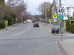
Having lived on Cadboro Bay Rd for just over three years, if most people are doing the speed limit, I would be truly surprised. I can definitely say that the width of the road encourages people to speed, as the picture to the right shows.

As I have mentioned before, pedestrian fatality percentage rises sharply between 30 and 60 km/hr. 5% to 85%, to be exact.

Cadboro Bay Rd width. Photo credit: John Luton
Looking north on Cadboro Bay Rd near Willows School. Photo credit: John Luton

So what can be done about it? A traffic circle is very needed, but before that there are three simple steps to keep speeds down:

  1. Bulge out the sidewalk at the crossing near Willows School. This shortens the crossing and puts the pedestrian beyond the parked car and in the sight of any oncoming vehicles.
  2. Bulge out the sidewalk at the two ends of the school zone. This narrows the roadway, slowing drivers down.
  3. Add bike lanes. The road in front of my house is ~11m wide, which is enough for two 3m travel lanes, two 1.5 m bike lanes and one 2m parking lane on the west side of the road. The loss of parking on the east side is mitigated by the fact that few people park on the east side of the road most of the day anyway.

Will any of this happen? I hope so. It will take a lot of work to convince council that these steps are needed to keep kids and people of all ages safe. Maybe they should be reading this pedestrian injuries report from Safe Kids Canada.

Bowker Creek Celebration Walk

Explanations before we head out

This Saturday was the Bowker Creek Celebration walk, co-hosted by the Oak Bay Community Association and Bowker Creek Initiative The walk started out at the upper parking lot of the Oak Bay Recreation Centre with it’s their freshly-painted lines and walked down the creek towards the mouth. The point of the walk was to showcase the need for a greenway or trail along the whole length, not just a few disconnected lengths. Sadly due having a generally crazy day, I was only able to make the first part, but I did take a few pictures, which you can see in my flickr set.

The demand for better access to waterways is not unique in the Bowker Creek area. Across North America there is an effort to “daylight” creeks, that is to remove the culverts and let them flow in natural streams along the surface. The High Country News near San Francisco recently ran a whole series on “rebooting” creeks in poorer neighbourhoods in San Francisco.


Site of Broom Pull – View Larger Map

Nearer to home, a group in Seattle won a victory about the Thorton Creek underneath the Northgate Mall. Too bad Hillside isn’t doing anything with the section of Bowker Creek that runs underneath the western edge of that mall as they expand. However, the BCI is hosting an ivy pull on the 27th of June between 10am and 12:30pm across the creek from the existing community gardens.

Bixi comes to Vancouver

Bike sharing station

The Montreal bike-sharing program is coming to Vancouver, for one day at least. The Georgia Straight is reporting that this Friday through Monday there will a test of the bikes on the seawall near Science World as part of Bike Month in the Vancouver region. You can see a map and the hours on the City of Vancouver’s official page about the program.

This isn’t the only place Bixi is spreading its wings to. Ottawa and Gatineau are also getting pilot projects, albeit a slightly more substantial one. This is run by the National Capital Commission (NCC) and comprises only 50 bikes right now. It is expected that if the pilot is successful, a larger rollout could come as early as 2010.

Given we have our own version of the NCC here in Victoria, the Provincial Capital Commission, and we such a tourist destination, where is the bike sharing project for Victoria? A few stations around downtown including at the cruise ship docks would allow tourists to discover all the great biking facilities here in Victoria and also maybe help the poor James Bay residents sleep better at night by cutting down on the diesel exhaust from buses.